Call us: +975 77 75 42 22

GASA LAYA TREK
ITINERARY
- DESCRIPTION
- TREKKING CHECKLIST
- ITINERARY
- INCLUSION
- EXCLUSION
The Laya-Gasa Trek is considered one of the most scenic treks in Bhutan, offering amazing views of some of the most pristine and unspoiled landscapes . This fourteen day, 217 km journey begins at Drukgyel in Paro and takes you through gorgeous alpine meadows, high mountain passes and dense sub-tropical jungles before terminating in Damji in Tashithang. The first five days of this trek follow the same route as the Jomolhari Trek through Jigme Singye National Park with beautiful views of Mt. Jomolhari, Jichu Drake and Tsherimgang. On the sixth day the path diverges and you will depart Lingshi for the camp site at Chebisa, a charming little village adorned with a beautiful waterfall.
Along the trail you’ll be able to spot indigenous animals such as the blue sheep and Takins; the national animal of Bhutan. You’ll travel through remote mountain villages inhabited by Layaps (people of Laya), a distinct segment of the Bhutanese society with unique culture, traditions and appearance. The trek also offers a day of relaxation at the famous Gasa hot springs that is sure to rejuvenate you. This is one of the more difficult treks offered in Bhutan due to the high altitudes and steep ascents and descents along the path. The best seasons to complete this challenge are in April-June and Mid-September-Mid-November.
Camping in extreme weather such as cold temperatures and snowy conditions can be expected and extremely enjoyable, Camping on the snow can be peaceful, picturesque and an out door adventure. All the accommodation while on Trek is twin sharing, double occupancy. Single occupancy in tents can be arranged on demand at an additional charge. All tents are Cold Weather Tents and designed for harsh weather and snowy conditions. Separate tents will be pitched for dinning, kitchen and rest room. On demand, a luxury camping facilities will be provided like bed and mattresses, warm shower tents, rest room with proper toilet pots, fishing equipment etc.
- Trekking Boots (broken in) & Camp Footwear (light shoes/sandles/trainers)
- Waterproof jacket, Down Jacket & Thermal inner wear
- Trekking trouser/pants & Shorts
- Gloves, Sunglass & Torch
- Sun hat, Woolen hat, neck warmer
- Sunscreen, Sanitizer & Trail mix
Daypack – The daypack you select must have the capacity for the items you may be carrying on a day’s walk: rain jacket, trousers, warm clothing, water bottle, camera equipment, washing items and other personal effects. A hip/waist strap provides additional comfort. You should consider daypacks of at least a 30 to 40-litre capacity. Horses will be carrying the rest of your luggage.
Day 1: Gunitsawa Village – Sharna Zampa
The trek starts from Gunitsawa Village where you will come across an army check post and will have to show your trek permit (provided by your tour operator) which has to be checked and endorsed by them. The campsite is located on the opposite side of the river, not far from Gunitsawa village where you will rest for the night.
Day 2: Sharna Zampa – Thangthangkha
You will continue the trek uphill through the river valley which gradually leads to a path descending towards a meadow in which your camp for the night will be set up.
Day 3: Thangthangkha – Jangothang
If you did not see Mt. Jomolhari the previous evening, you will wake up to a stunning view of the mountain the next morning. The trek continues up the Paro Chhu valley which widens into patches of alpine meadows and scanty growths of forest. You will cross another army checkpoint along the way and enjoying spectacular views of high mountain ridges and snow-capped peaks. You will pass the Soe, Takethang and Dangochang village on your way. After you reach Jangothang, your campsite,you can take rest and enjoy a spectacular view of Mount Jomolhari.
Day 4: Jangothang Halt
This day will be your day to rest or you can opt to go for short day hikes with great views of lakes and snow capped mountains such as Jomolhari and Jichu Drake. If lucky, you might spot a flock of blue sheep on the upper slopes of the valley. Jangothang is a perfect environment for you to acclimatize.
Day 5: Jangothang – Lingshi
This will be one of the longest days of the trek. You will start the trek climbing uphill for about half an hour towards the Nyelila pass at 4,870m. You will see herds of blue sheep grazing on the slopes of the mountains. From the pass you will have spectacular views of Mt. Jomolhari, Jichu Drake and Tsherimgang, all of them rising above 7,000m. Then it’s a gradual descent towards the camp coming across some of the yak herder’s tents, made from yak wool. The herders use these tents while travelling to various pastures for their yaks. As you come down towards the Lingshi base, a beautiful U-shaped valley, you will have a wonderful view of Lingshi Dzong . Tserimgang and its glaciers rise up at the north end of the valley.
Day 6: Lingshi – Chebisa
This day will be the shortest walking day, and you can really take it easy,walking at a slower pace, enjoying the views around. Shortly after starting the trek, you will reach a chorten below Lingshi Dzong. Here, you have the choice of staying on the main trail or taking a detour up to the Lingshi Dzong (4,220m), which sits right atop a high ridge. In addition to a very special atmosphere of mystic tranquility, Lingshi Dzong provides a great view over the valley. Walking further, you will be passing the villages of Lingshi and Goyul. In Goyul, the stone houses are clustered together to form a small compact village that is unusual in Bhutan where settlements are usually scattered. On reaching the campsite at Chebisa you will have plenty of time to visit the village houses if you feel up to it. There is also a beautiful waterfall located right behind the village that is worth the walk.
Day 7: Chebisa– Shomuthang
The next morning starts with a long climb uphill, behind Chebisa Village (2-3 hours) through a wide pastureland towards Gobu La pass. Once you have crossed the Gobu La pass (4,410m), you will then start your descent into the valley, climb uphill again for a while, before descending towards Shakshepasa valley (3,980). A short walk will then lead you to the campsite at Shomuthang.
Day 8: Shomuthang – Robluthang
You will start the trek by climbing up the valley to view Kang Bum (6,526 m) and some edelweiss. After two hours of trekking, you will reach Jhari La (4,750m), from where you catch the first glimpse of Sinche La, the pass you will be crossing the day after. The snow capped mountain in the north is Gangchhenta 6,840m, better known as “the Great Tiger Mountain.” The camp for the night is by the river and is called Tsheri Jathang located in a beautiful wide and remote valley. Herds of takin- the national animal of Bhutan migrate to this valley in the summer and remain here for about four months. The valley has been declared a takin sanctuary. You will then have to walk a little further to reach Robluthang campsite.
Day 9: Robluthang – Limithang
The trek next day will start with a 4 hour hike through a boulder field before getting to Sinche La at 5,005m-the final and highest pass for this trek. As you descend the far side of the pass you will see an impressive terminal moraine and a glacial lake at the foot of the valley. You can see classic examples of lateral moraines where the glacier has pushed rocks up both sides of the valley. Below the moraine, you cross the Kango Chhu and soon reach the Limithang campsite. The peak of Gangchhenta towers over the campsite even though it’s quite a distance away.
Day 10: Limithang – Laya
You will walk downhill all the way along a narrow, winding river valley. After a while, the trail will take you through a densely forested region leading you to the west side of Laya village with a small community school and a BHU unit-your campsite for the night. From this side of the village, you will have spectacular views of Mt. Gangchhenta and catch Mt. Masagang.
Day 11: Laya – Koina
The trail winds up and down along the river valley of Mo Chhu with breath-taking views of the raging river, feeder streams and waterfalls.The hike will eventually lead you to Kohi Lapcha at 3.300 m.You will then start walking downhill towards Koina Chhu, and towards your campsite.
Day 12: Koina – Gasa
This will be the last major climb of the Laya Gasa Trek. You will cross Bari La (3,740m), after which the trail will descend until you reach Gasa village (2,770m), where you will find a handful of small restaurants and shops. There is a second campsite close to Gasa Dzong. You will have the option to decide whether you want to stay in the campsite near Gasa Dzong or walk for another hour to the Gasa Tsachu (hot springs) and relax in the rejuvenating spring water. The Gasa Tsachu is one of the most popular hot springs in Bhutan with hundreds of local visitors flocking to the site every year.
Day 13: Laya Gasa Trek – The end
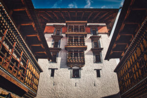
This trek ends in Gasa, a remote village, far away from construction noise, buildings and noise pollution, home to a distinctive and architecturally unique Dzong and equally interesting locals.
- All Trekking Meal during the Trek
- One Trekking Expeditions Leader
- Horsemen as per the group size
- Helper as per the group size
- Group Medical Kit
- Good Quality accommodation throughout. The use of a world expedition trek pack which includes a quality sleeping bag, and insulated mat
- All Park entrance Fees and Trekking Permits
- Horses to carry 20 Kgs personal equipment
- International Airfare
- Alcohol
- Tips/gratuities
- Cost arising out of Flight Cancellation/road blockades/ landslides and events beyond our control
- Expenses of personal nature and any other expenses not mentioned in the above cost
RJD TOURS
&
TRAVEL
QUICK LINKS
TOP DESTINATION

+975 - 77 75 42 22
POPULAR TOUR
This tour covers all of the major tourist destinations in the Western part of Bhutan. It starts and ends in Paro .